New map collection illustrates centuries of change and endurance
August 26, 2025
A recent gift to the library brought a collection of remarkable maps, along with the remarkable story of the man who collected them.
Back in 1964, Dr. Stevo Julius (1929-2025) left his home in Zagreb, Yugoslavia, emigrating to the United States to take up a position in the University of Michigan health system. Upon his death 60 years later, he left behind a substantial legacy. Among the highlights: research breakthroughs on hypertension and metabolic syndrome that helped establish the university as a global leader in cardiovascular research; a research professorship in his name to honor these achievements; a thriving family and a scientific community nurtured over many decades by Julius and his wife, Susan; and a personal history of fighting fascism in his youth as a Jewish member of the Partisan movement during World War II.
And though he became a Michigander and a committed Wolverine, the homeland he defended in his youth remained a source of fascination, "a place he regarded as almost magical," according to his obituary.
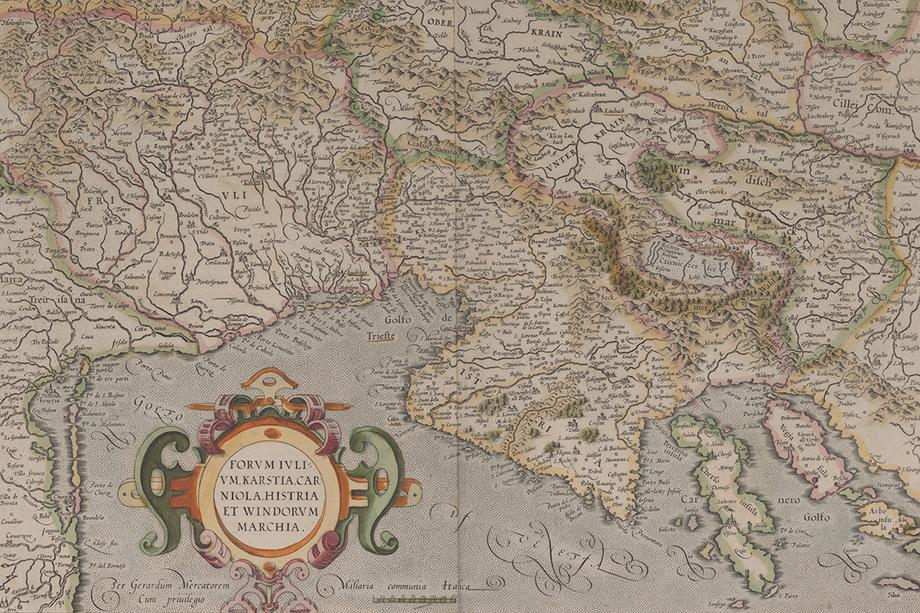
That fascination contributed to what became an ongoing adventure: the pursuit of antique maps depicting the Balkan Peninsula and nearby regions. Julius was taken by the detail and craftsmanship of these beautiful artifacts, some of which were drawn by Europe's most influential cartographers, including Gerard Mercator, Abraham Ortelius, and Nicholas Sanson.
It's possible he was also fascinated by mapmaker perspectives predating the 20th-century conflicts that repeatedly destabilized the region's national borders. There's a reason why "Balkanize" — meaning "to divide (a region) into a number of smaller and often mutually hostile units" (Oxford English Dictionary, Second Edition) — became a verb in that era.
During Julius's lifetime his hometown, Zagreb — a city founded in 1134 — went from being part of the Kingdom of Yugoslavia (1929-1941), to the so-called Independent State of Croatia (under Nazi occupation, 1941-1945), to communist rule within the Federative Peoples Republic of Yugoslavia (1945-1963) and then the Socialist Federative Republic of Yugoslavia (1963-1991), before declaring independence as the Republic of Croatia (1991-present).
Within this recitation lies wars both hot and cold, and widespread displacement and disruption of the populace.
Today some among his collection of maps — 135 in all, dating from the 16th-18th centuries — reflect contemporary national boundaries and names more so than their 20th-century analogs, reminding us that though borders among nations can abruptly shift, their landscapes, coastlines, languages, and cultures are more persistent.
Julius counted himself among the displaced. It was no easy matter to emigrate from communist Yugoslavia, and for decades thereafter he could only return as a tourist, said his wife Susan. "It would not have been possible at that point for him to get involved in the medical community he had left behind," she added.
That changed after the Croatian War of Independence, which ended in 1995. After his retirement in 2005 he developed working relationships between U-M and the School of Medicine at the University of Zagreb, his alma mater. His work there was a return to his roots, and brought about further contributions to the field he'd already done so much to advance.
His maps, yet another contribution to research and scholarship, will also bring lasting benefit to the university community he served and loved for more than five decades.
Map Curator Anna Rohl is celebrating their arrival, and notes that they fill gaps in the current collection. Because of their proximity to the Balkan Peninsula, maps of Italy as well as the rest of Europe also feature in the collection.
"We plan to digitize these beautiful maps within the next year, where they'll join our online collection which is open to viewers all over the world," she said. Cataloging each item — that is, creating the descriptive information that helps researchers discover them — will take up to two years.
by Lynne Raughley

"Forum Iulium, Karstia, Carniola, Histria et Windorum Marchia," designed by Gerard Mercator and published by Cornelis Claes in 1610.